Файл:DjoudjNASA.jpg
Нет версии с бо́льшим разрешением.
DjoudjNASA.jpg (560 × 305 пкс, размер файла: 79 Кб, MIME-тип: image/jpeg)
| Этот свободный медиафайл находится на Викискладе?, хранилище изображений и мультимедиа для использования во всех проектах Фонда Викимедиа. Cведения об этом файле показаны ниже. |
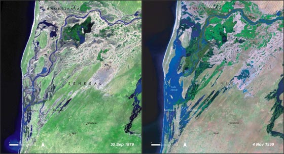
| Описание | Lake Djoudj during the Sept. 1979 drought (left) and during the Nov. 1999 flood (right). http://landsat.gsfc.nasa.gov/images/archive/f0011.html In August 2006, the United Nations Environment Programme (UNEP), released an atlas entitled: "Africa's Lakes: Atlas of Our Changing Environment." The atlas relies heavily on Landsat imagery from the past 34 years to show changes in lakes around the African continent. Above, are two Landsat images of the Djoudj Sanctuary in Senegal that are featured in the atlas. The atlas tell us: "Situated in the Senegal river delta, the Djoudj Sanctuary is a wetland of 16 000 ha, comprising a large lake, referred to as Lake Djoudj in this publication, surrounded by streams, ponds and backwaters. These two images show the Djoudj Sanctuary before and after the construction of the Diama Dam." "The image from September 1979 shows the impact of drought on the Djoudj Sanctuary, while the image from November 1999 shows rejuvenation of the sanctuary wetlands due to the significant floods of that year. The two images vividly depict the impact of climate variability on the Djoudj Sanctuary—and demonstrate the broader need for close monitoring of the impacts of climate variability and climate change on lake environments." |
| Дата | August 2006 September 1979 November 1999 (5 октября 2006 (в соответствии с данными Exif)) |
| Источник | NASA [1] |
| Автор | Неизвестен |
| Этот файл находится в общественном достоянии (англ. public domain), так как он был создан NASA (Национальным управлением по аэронавтике и исследованию космического пространства). Политика авторского права NASA гласит, что «Материал NASA не защищается авторским правом, если не указано иное». (См. Template:PD-USGov, страницу политики авторского права NASA или политику использования изображений JPL.) | ||
 |
Предупреждения:
|
История файла
Нажмите на дату/время, чтобы увидеть версию файла от того времени.
| Дата/время | Миниатюра | Размеры | Участник | Примечание | |
|---|---|---|---|---|---|
| текущий | 20:03, 16 августа 2007 | | 560 × 305 (79 Кб) | Ji-Elle | Lake Djoudj during the Sept. 1979 drought (left) and during the Nov. 1999 flood (right). http://landsat.gsfc.nasa.gov/images/archive/f0011.html In August 2006, the United Nations Environment Programme (UNEP), released an atlas entitled: "Africa's Lakes: |
Использование файла
Следующая страница использует этот файл:
Глобальное использование файла
Данный файл используется в следующих вики:
- Использование в ar.wikipedia.org
- Использование в az.wikipedia.org
- Использование в ca.wikipedia.org
- Использование в en.wikipedia.org
- Использование в en.wikinews.org
- Использование в fr.wikipedia.org
- Использование в hy.wikipedia.org
- Использование в mt.wikipedia.org
- Использование в ru.wikipedia.org
- Использование в www.wikidata.org