Файл:Mayotte, vue par Sentinel 2 (cropped).jpg

Исходный файл (4100 × 4381 пкс, размер файла: 11,67 Мб, MIME-тип: image/jpeg)
| Этот свободный медиафайл находится на Викискладе?, хранилище изображений и мультимедиа для использования во всех проектах Фонда Викимедиа. Cведения об этом файле показаны ниже. |
Краткое описание
| Описание |
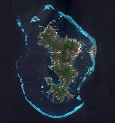
Français : L'ile de Mayotte dans l’océan indien vue par le satellite Sentinel 2, le 14 aout 2021.
English: Mayotte island (Indian Ocean) photographed by satellite Sentinel 2 on 14th August 2021. |
| Дата | |
| Источник | https://phototheque.cnes.fr/cnes/media/68576 |
| Автор | European Space Agency / CNES |
| Другие версии |
_(cropped).jpg)

.jpg?uselang=ru)
| Местоположение камеры | | Это и другие изображения по их местоположению на OpenStreetMap |
|---|
.jpg¶ms=-12.843056_N_0045.138333_E_globe:Earth_type:camera__&language=ru)
Лицензирование

|
This image contains data from a satellite in the Copernicus Programme, such as Sentinel-1, Sentinel-2 or Sentinel-3. Attribution is required when using this image.
Атрибуция: Contains modified Copernicus Sentinel data 2021
The use of Copernicus Sentinel Data is regulated under EU law (Commission Delegated Regulation (EU) No 1159/2013 and Regulation (EU) No 377/2014). Relevant excerpts:
Free access shall be given to GMES dedicated data [...] made available through GMES dissemination platforms [...].
Access to GMES dedicated data [...] shall be given for the purpose of the following use in so far as it is lawful:
GMES dedicated data [...] may be used worldwide without limitations in time.
GMES dedicated data and GMES service information are provided to users without any express or implied warranty, including as regards quality and suitability for any purpose. |

|
Это изображение было оценено в соответствии с критериями ценных иллюстраций и было признано наиболее ценным изображением в категории Mayotte island, France - satellite view.. Вы можете просмотреть его номинацию на странице Commons:Valued image candidates/Mayotte, vue par Sentinel 2 (cropped).jpg. |
.jpg)
История файла
Нажмите на дату/время, чтобы увидеть версию файла от того времени.
| Дата/время | Миниатюра | Размеры | Участник | Примечание | |
|---|---|---|---|---|---|
| текущий | 11:52, 17 февраля 2022 | | 4100 × 4381 (11,67 Мб) | Don-vip | File:Mayotte, vue par Sentinel 2.jpg cropped 18 % horizontally, 12 % vertically using CropTool with lossless mode. |
Использование файла
Следующая страница использует этот файл:
Глобальное использование файла
Данный файл используется в следующих вики:
- Использование в ar.wikipedia.org
- Использование в arz.wikipedia.org
- Использование в ast.wikipedia.org
- Использование в az.wikipedia.org
- Использование в ca.wikipedia.org
- Использование в ceb.wikipedia.org
- Использование в ce.wikipedia.org
- Использование в cy.wikipedia.org
- Использование в de.wikivoyage.org
- Использование в eo.wikipedia.org
- Использование в es.wikipedia.org
- Использование в fr.wikipedia.org
- Использование в fr.wikinews.org
- Использование в fr.wikivoyage.org
- Использование в ga.wikipedia.org
- Использование в gl.wikipedia.org
- Использование в hy.wikipedia.org
- Использование в ig.wikipedia.org
- Использование в mg.wikipedia.org
- Использование в no.wikipedia.org
- Использование в oc.wikipedia.org
- Использование в pl.wikipedia.org
- Использование в ps.wikipedia.org
- Использование в tl.wikipedia.org
- Использование в tt.wikipedia.org
- Использование в vi.wikipedia.org
- Использование в www.wikidata.org
.jpg)