Файл:PIA21130 Signs of Schiaparelli Test Lander Seen From Orbit.gif

Исходный файл (1132 × 781 пкс, размер файла: 1,43 Мб, MIME-тип: image/gif, закольцованный, 2 фрейма, 2,0 с)
| Этот свободный медиафайл находится на Викискладе?, хранилище изображений и мультимедиа для использования во всех проектах Фонда Викимедиа. Cведения об этом файле показаны ниже. |
Краткое описание
| Описание |
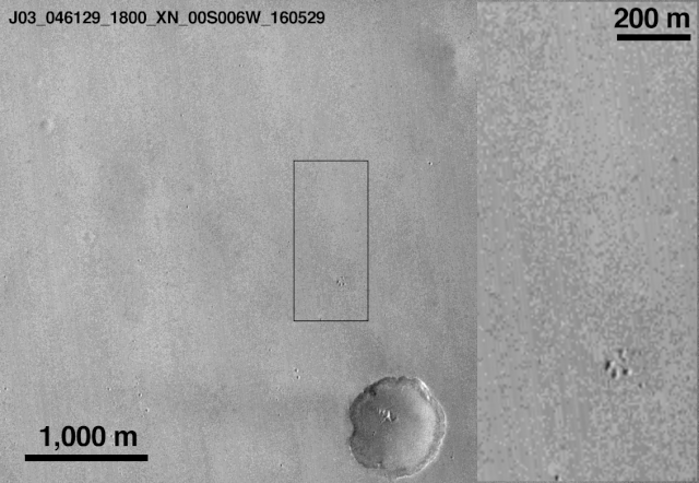
English: This comparison of before-and-after images shows two spots that likely appeared in connection with the Oct. 19, 2016, Mars arrival of the European Space Agency's Schiaparelli test lander.
The images were taken by the Context Camera (CTX) on NASA's Mars Reconnaissance Orbiter on May 29, 2016, and Oct. 20, 2016. The area indicated with a black outline is enlarged at right. The bright spot near the lower edge of the enlargement is interpreted as likely to be the lander's parachute, which was deployed and then released during the descent through the Martian atmosphere. The larger dark spot near the upper edge of the enlargement was likely formed by the Schiaparelli lander. The spot is elliptical, about 50 by 130 feet (15 by 40 meters) in size, and is probably too large to have been made by the impact of the heat shield. The location information confirmed by this image will aid imaging the site with the High Resolution Imaging Science Experiment (HiRISE) camera, providing more details to use in interpretation. The main image covers an area about 2.5 miles (4 kilometers) wide, at about 2 degrees south latitude, 354 degrees east longitude, in the Meridiani Planum region of Mars. The scale bars are in meters. North is up. The before and after images are available separately as Figure 1 (from CTX observation J03_046129_1800) and Figure 2 (from CTX observation J08_047975_1779). CTX was built by and is operated by Malin Space Science Systems, San Diego. NASA's Jet Propulsion Laboratory, a division of Caltech in Pasadena, California, manages the Mars Reconnaissance Orbiter Project for NASA's Science Mission Directorate, Washington. |
| Дата | (published) |
| Источник | Catalog page · Full-res (GIF) |
| Автор | NASA/JPL-Caltech/MSSS |
| Другие версии |
|


| Место на Марсе | Это и другие изображения по их местоположению на Картах Google |
|---|
Это изображение или видеозапись внесены в каталог Лаборатории реактивного движения НАСА под идентификатором (Photo ID): PIA21132. Этот шаблон не указывает на правовой статус данной работы. По-прежнему необходим нормальный шаблон лицензий. См. Commons:Лицензирование. Другие языки:
|
 |
This media is a product of the Mars Reconnaissance Orbiter mission Credit and attribution belongs to the MRO Context Camera (CTX) team, NASA/JPL-Caltech/MSSS |
Лицензирование
| Этот файл находится в общественном достоянии (англ. public domain), так как он был создан NASA (Национальным управлением по аэронавтике и исследованию космического пространства). Политика авторского права NASA гласит, что «Материал NASA не защищается авторским правом, если не указано иное». (См. Template:PD-USGov, страницу политики авторского права NASA или политику использования изображений JPL.) | ||
 |
Предупреждения:
|
История файла
Нажмите на дату/время, чтобы увидеть версию файла от того времени.
| Дата/время | Миниатюра | Размеры | Участник | Примечание | |
|---|---|---|---|---|---|
| текущий | 18:28, 21 октября 2016 | | 1132 × 781 (1,43 Мб) | Ely1 | User created page with UploadWizard |
Использование файла
Следующая страница использует этот файл:
Глобальное использование файла
Данный файл используется в следующих вики:
- Использование в de.wikipedia.org
- Использование в en.wikipedia.org
- Использование в es.wikinews.org
- Использование в et.wikipedia.org
- Использование в fa.wikipedia.org
- Использование в fr.wikipedia.org
- Использование в he.wikipedia.org
- Использование в it.wikipedia.org
- Использование в ru.wikipedia.org